Monday, March 08, 2010

A Needle in a Haystack

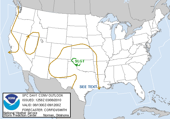
This morning I woke up and noticed the Storm Prediction Center's Day One Convective Outlook. A simple slight risk area over northwestern Oklahoma with a 2% risk for tornadoes. I already knew I couldn't storm chase (though I don't consider myself a storm chaser by any stretch of the imagination), but being in Norman, Oklahoma, I know many friends who are devoted storm chasers. Dynamics weren't bad (30 knot low-level jet), decent wind shear, and a little CAPE. Dew points were severely lacking though, and this lack of moisture was one of the biggest factors keeping most recreational storm chasers from going out today.

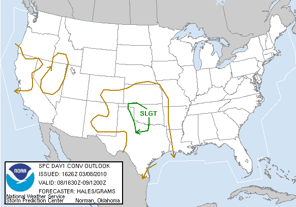
Fast forward to 11:30 am. Over lunch, me and a friend looked at the setup (but neither of us are available to chase). CAPE was really starting to ramp up, but in Texas, but both of us came to the conclusion that while today was a solid slight risk day, not something we would want to chase (linear mode with little tornado threat). The SPC had shifted the slight risk area farther south and east.

I finished up classes today at around 2:30 pm central time, and examined the weather conditions yet again. I held my previous conclusion that the event had potential to produce severe weather (in Texas), but was not chaseable. At around 5:00 pm, I left my apartment to pick up a friend from the Oklahoma City airport. I was approaching the I-235/I-35 interchange when I got a phone call that changed the day. "Jason! There is a huge tornado on the ground near Elk City!" My immediate reaction was more astonishment than anything else. How could a tornado, especially a strong one, form in western Oklahoma? Looking back at the radar, it's kinda hard to pinpoint exactly where the tornado was located (it's somewhere in the red "blob").


In conclusion, any storm chasers who "missed" this tornado thinking there wouldn't be anything out there today, should not feel bad for missing this storm. It was virtually impossible to predict anything like this would have developed. With the SPC only putting out a 2% risk for tornadoes (which was still quite accurate considering there was one isolated tornado), it's no surprise many people didn't chase. The only chasers that saw this tornado were extremely devoted (and lucky) storm chasers. The severe weather season has a long way to go!

Sunday, March 07, 2010

Spring is in the Air

Now that spring is finally here (meteorologically though not astronomically), WHEN IS IT GOING TO WARM UP!!! If you're like me, you're probably quite sick of this cold, miserable winter we have had, thanks to a largely negative Arctic Oscillation, but forecasts from the Climate Prediction Center (CPC), are beginning to show we could be moving away from this negative trend. This trend will produce warmer conditions (or is that just spring?).


The GFS is developing what I consider to be the first "spring-like" weather system over the high plains on Monday. You can see from the image below, that a 996 mb low causes decent warm air advection inland across Texas and into southwestern Oklahoma. There is a slight possibility of a few severe thunderstorms, but due to limited moisture, I don't expect anything significant, maybe a few severe reports at best.


So how long until severe weather season really cranks up? Well if you look at the 00z March 7 run of the GFS (http://hoot.metr.ou.edu/models/gfs/surf/dewp), it looks like it could be a while. Dry air spills into the plains following the storm system forecast to pass through this week with the 60 F dew point line moving very far south. Also, if you look at the sea surface temperatures in the Gulf of Mexico (10 C is about 50 F, 15 C is about 59 F, 20 C is about 68 F, and 25 C is about 77 F), the Gulf waters are quite cool (though interestingly, you can make out the loop current in the southeast Gulf of Mexico), this means there is not very much heat content in the Gulf, which will limit warm air and moisture advection, a key ingredient for severe weather development. Looking at this, we are probably in for a quiet start of severe weather season.


So what do I predict? I am predicting a slow warming of temperatures across the United States, but slower than normal because of the lack of heat content over the Gulf of Mexico and a negative, but becoming more positive, Arctic Oscillation.

This is my first "serious" discussion about weather and climate and I'm running on only one and a half semesters of actual meteorology courses (though I have been studying the weather for quite some time), so if you have questions or comments, feel free to leave your comments, but please don't be to harsh on me! Just point out any errors (kindly) if you feel something is incorrect.